P-51B Mustang: North American’s Bastard Stepchild that Saved the Eighth Air Force

Hi Bill,

Suggestion - note that the 'point of origin is ~ 52degrees for East Anglia. The CR would originate 2degrees above Schweinfurt.

Hm, I've got to admit that I have no idea what you mean, perhaps because I don't recognize the abbreviation "CR".

Second note - plots before D-Day when P-47 operating on 305gal internal fuel, or before mid March when 2x10⁸gal capability arrived could be revealing.

Third note - D-Day screws context up when 9th AF P-47s arrive on the continent and continuously east.

Excellent input, I've eliminated the post-D-Day claims and split up the 1944 data at the mid-March point:

Luftwaffe claims against P-47s V3.png

Regards,

Henning (HohUn)
 
Hi again,

Excellent input, I've eliminated the post-D-Day claims and split up the 1944 data at the mid-March point:
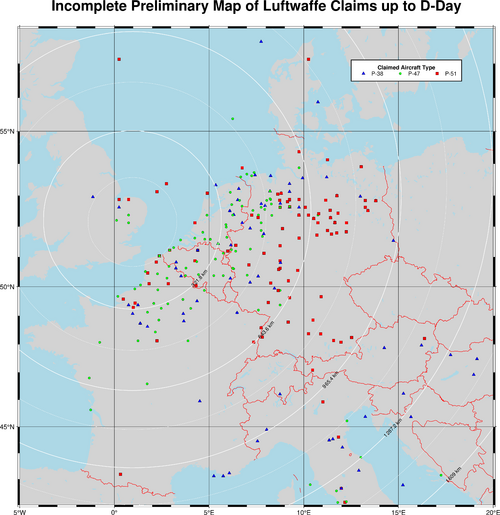
Now I've used GMT to create an actual map for the three main US fighter types (P-38 - blue, P-47 - green, P-51 - red) as claimed by the Luftwaffe up to and including on D-Day. The usual caveats apply, but I've so far been unable to figure out how to give the map a nice legend <edit:>Now I have, so I'm replacing the legend-less map here</edit>:

europe_map.png.png

Oh, and the odd kilometer rings are even 100 mile rings! :) Centered on Wattisham, as before.

Regards,

Henning (HoHun)
 
Last edited:
Hi Bill,

Third note - D-Day screws context up when 9th AF P-47s arrive on the continent and continuously east.

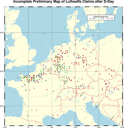
Here's a map showing (half of) the post-D-Day claims ... I'd say you hit the nail on the head there:

europe_map_2.png

One shortcoming of the map is that where the position data is grid-based, multiple claims can fall onto the same grid square, looking exactly like only a single claim. If different types are involved, that's sort of visible because you might be able to see two overlaid symbols, but it's another reason to consider these maps preliminary.

Regards,

Henning (HoHun)
 
Hi again,


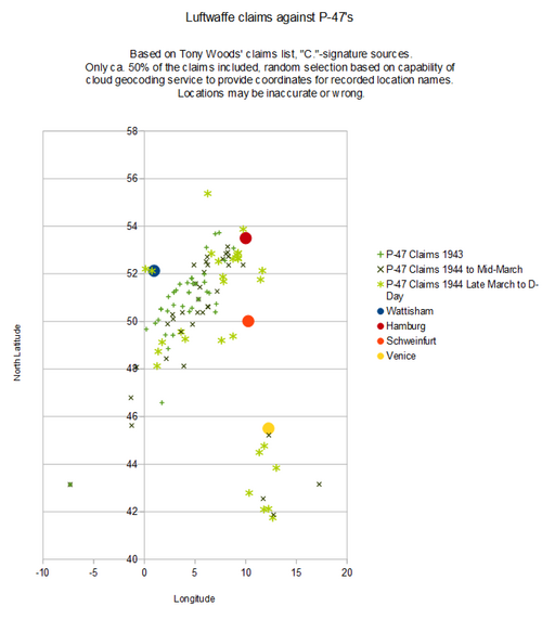
Well, it struck me that instead of a breakdown by year, we're actually more interested in the pre-D-Day situation, so I made a new version of the diagram.

I also restricted the selection of claims to those with a "C." signature in Tony Woods' list, which I think are the official records and not secondary sources like Prien, in the hopes of getting more accurate location information. The ratio of location-codable claims is still around 50%, though. Additionally, I removed the Wintergerst claim from June 30, 1943, as it's clear that the main grid square information is missing, and he was almost certainly fighting over the Netherlands with the rest of JG 1 that day.

So here it is:

View attachment 733527

Regards,

Henning (HoHun)
Much better story here. 1943 losses show max Combat Radius (CR) for the 108gal. Pre Day show the extensions of single 150 and dual 108s to extend range.

The Venice vicinity I would speculate are spring 44 325FG before they converted to Mustangs and probably D-15 equivalent w 2x10⁸gal pylon mounted.

Great presentation
 
Last edited:
2deg of longitude is just 120NM/200km. A fairly credible genuine navigation error for VFR flight at the time that could explain any discrepancy b/w claims and reported losses.
120nmi is still ~30min flying time for these birds at best range cruise. That's pretty freaking lost in your navigation errors! +-15 min is a much more reasonable error and is only 60nmi or 1deg longitude.
 
I do agree but see it more as an angular deviation from home base. The guys here will tell us better.

If 120mmi = r*Alpha with Alpha being the deviation, it´s an alpha for a range of
r =120 / 0,3 = 400nmi range (0,3 rad = 17 deg)
r=120/0,15= 800nmi (0,15 rad = 8deg)
r=120/0,075= 1600nmi (0,075 = 4 deg)

As you can see, the cumulative error in direction change can be fairly low (considering that all changes are made in the same angular direction (hence clockwise or anticlockwise but not both) to have that resulting error.

Let´s say that Tony, a fresh pilots with a dozen of mission is flying his 51 on a 400nmi mission with 3 consecutive planned direction change and make a 6 deg error at each. Then the cumulative angular error would have seen him offset of 120nmi at his final planned destination ;)

If then Tony, a not as fresh pilot, with 30 missions logged, is flying that day an 800nmi range mission with 6 consecutive planned direction changes, with an error of only 1,5 deg at each turn, he will still be offset of 120nmi at the end leg of his journey

I do agree that 120nmi is way too much for our present navigational usage, but please, keep in mind that pilot´s charts were not the kind you´ve got for cheap today, VFR was not always VFR granted all the way... And, today, generally, nobody is trying to shoot you down,

By the way, I just ordered the book.
 
Last edited:
Back
Top Bottom